Hiking the Subway in Winter
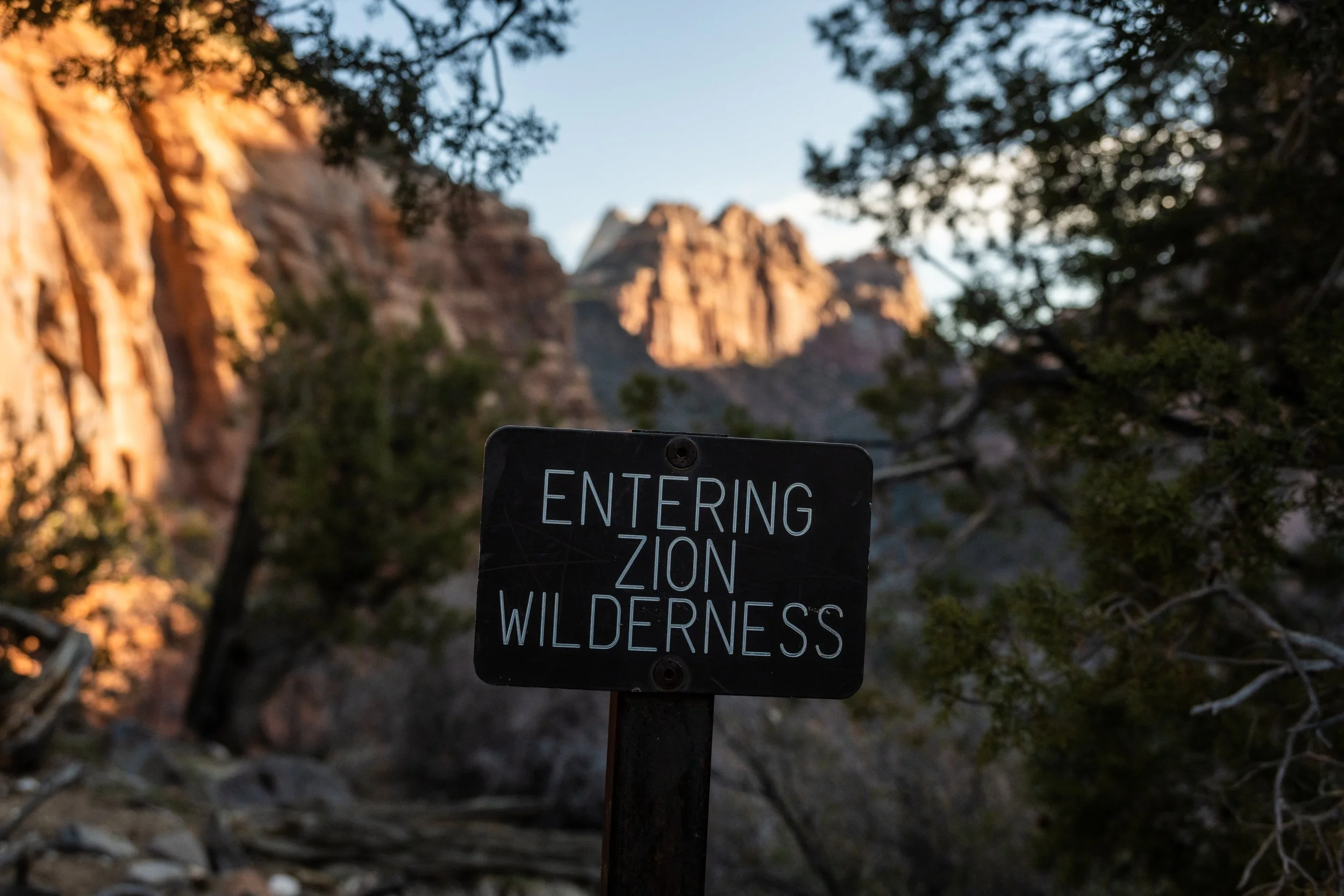
Always a good day when you get to pass a sign like this.
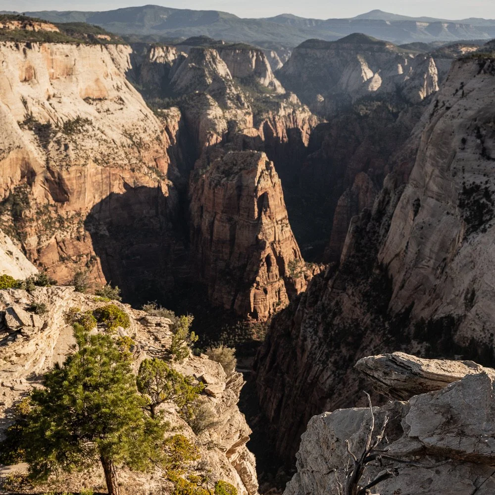
Park: Zion National Park
Distance: 9 Miles
Elevation: ~1700 feet
Difficulty: Strenuous
Trailhead: Left Forth of North Creek Trailhead

Hiking through the creek
Zion hosts many beautiful trails as well as many routes. The routes in Zion tend to follow creeks or rivers and are technically unmaintained trail because you’re simply hiking in water up a canyon. One such route is up the Left Fork of North Creek to the Subway slot canyon. The area around this location is fragile and would easily get trampled by too many users so the park manages a permit system for the hike. And it’s popular. We’ve tried once or twice to get passes through the park lottery system with no luck. And so it has remained on our radar to try to go every trip we have taken to Zion.

We hiked up and through this waterfall!

Hiking through shallow waters up to the Subway
This past spring break, we were visiting Zion after having finished all the official miles in Capitol Reef (woot-woot!) and before a backpacking trip in the Grand Canyon. Our spring break is early, toward the beginning of March. The weather can be extra dicy in Utah around this time and as luck would have it, they were in a deep cold snap while we were visiting. After hiking for days in Capitol Reef in snow and cold wind, we did an 8 mile hike in Bryce Canyon where we started the hike at 10 degrees. Just in case you hadn’t noticed, that is one tiny blip away from single digits. It was darn cold.
As we headed into Zion, I just didn’t think I could handle hiking up a creek in the temperatures we’d be facing. I knew we could rent gear that would keep us dry but I did not have any faith at all that it could be a comfortable day. We had some experience hiking the Narrows Top Down in cold temps and that was hanging over me. Knowing we’d still be facing the cold on our backpacking trip into the Grand Canyon, I asked Kelly if we could just not worry about trying to get permits for the Subway. I convinced him I had a plan for another hike we could do that would get us some new miles. In fact, I had not one but two backup plans.
On our way to get information from the backcountry office, we ran into a ranger that was sent out to let people know more parking had opened up in the main canyon. We must have made a face that made him instantly trust us (the canyon is beautiful and we love it but it’s the touristy part of the park so our lack of interest in entering clued him in that we were there for something more). We asked if he had any other information about backcountry areas and he was happy to talk. I ran Plan A by him. It was technically possible, he said, but we’d have to hike an extra 5 miles and would be in several feet of snow the whole time. We’ve done that once already in Zion when I insisted we could handle ‘a little snow’ and we day hiked the West Rim and Telephone Canyon in February. So Plan A got crossed off the list. Then we ran Plan B by him—an area much less likely to be covered in snow but one with some potential issues in getting out there, namely mud. He grimaced and said he had just recently had to abandon a Jeep up there due to the mud. Scratch Plan B off the list—our rental car was not going to make it through those road conditions. Kelly gave me a mischievous, curious look to check to make sure it was OK to ask about the Subway and I gave him subtle approval. And so he asked. And the ranger said, “Sure, that would be great right now!” We laughed. And promptly headed to the backcountry office where we were second in line. The people in front of us were scrambling to change backcountry campsites due to the cold. When it was our turn, we quickly confirmed that Plans A and B were off the table. And then we asked about permits for the Subway the next day. Truthfully, we thought there would be no permits available. It’s such a popular hike and it was already late afternoon by that point. The ranger perked up right away and said we could absolutely do that. She said that we were the only people to ask for permits for the following day. This crazy busy hike and we were the only ones to get to go. I mean, sure, they expected the thing to be covered in ice and the water was thigh deep and it would get down into the 20s that night. But whatever, we were going to the Subway. Adrenaline kicked in and we scurried around town renting gear. Zion Adventure Company hooked us up with Goretex pants, two pairs of neoprene socks each, and canyoneering boots that would fit our newly expanded shoe sizes. We enjoyed caprese salad and pizza at Zion Pizza and Noodle and packed up our gear for an early-ish start the next day.
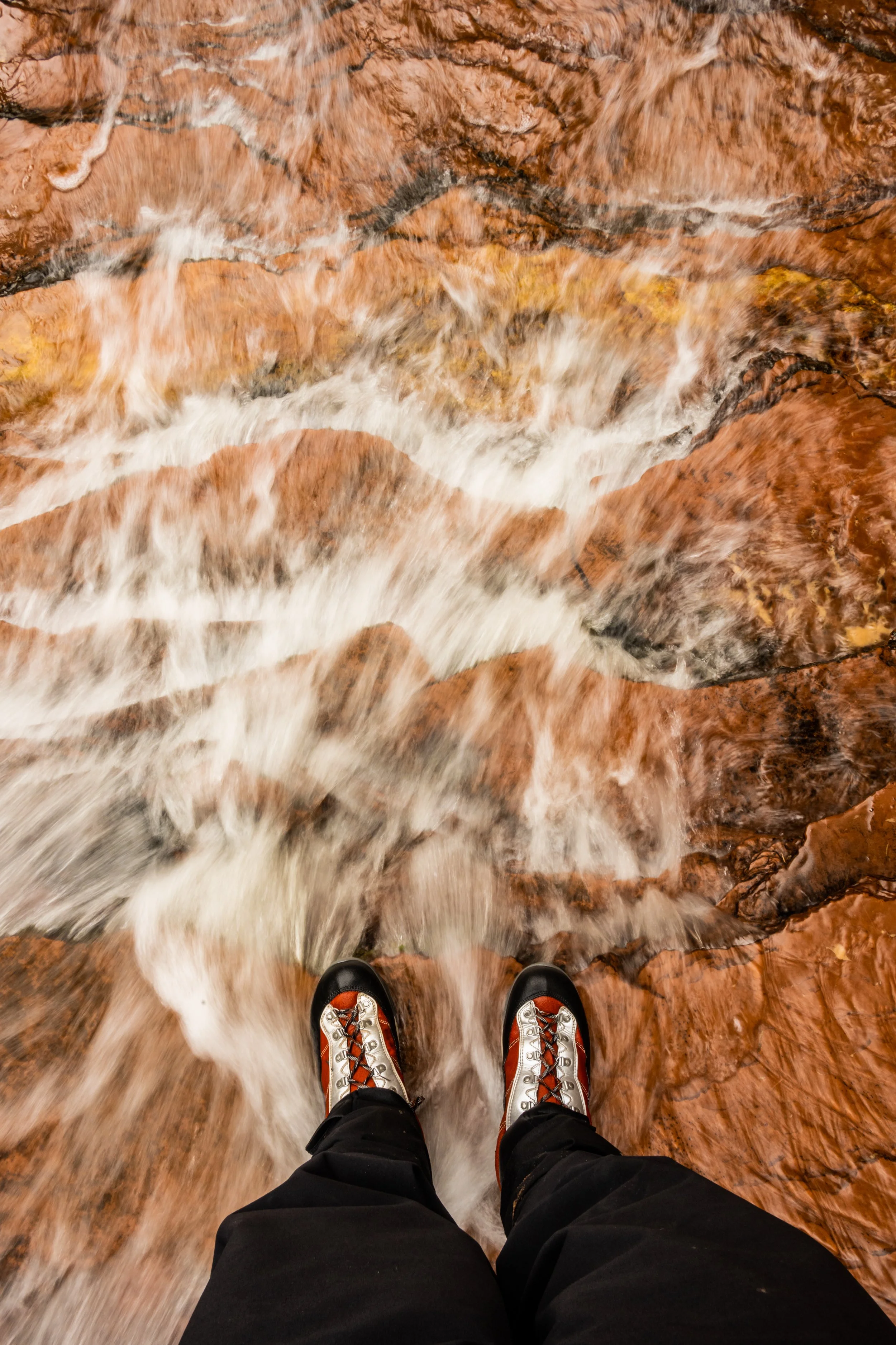
Water swirling under Kelly’s feet
We camped in the back of our rental car that night and woke up to frozen breath on the inside of the windshield. In moments like these, it can be easy to doubt your training, experience, and all around life choices. But we persisted. We were the only ones at the trailhead. The ranger we had spoken to at the backcountry office let us know she was on patrol duty for the Subway that day so we expected to eventually run into her. But we had the entire place to ourselves. We carefully followed the trail, checking occasionally on our Gaia GPS route as many people have made spur trails throughout the area. Eventually the trail just dumps you into a gorge. It’s about 400 feet down in 1/3 of a mile. And then you get your first creek crossing! We waded in cautiously and were surprised to find we didn’t even feel the cold of the water. The path is quite rugged for the entire rest of the hike up to the Subway. As we said, there is no official trail. You can just march up the river or criss cross it and look for side trails people have made on the shores. We’d cruise for about 1/10th of a mile and then have to slow down to scramble over boulders or climb up and around a steep cliff. We hiked up and through waterfalls and around deep pools of water. Kelly pulled me up a few big rocks. The hiking was just really slow going. We use a GPS tracker but in a canyon like this, it’s not reliable and so although we could see we were making progress it was three steps forward, two steps back on the tracker.
It was very cold in the canyon!
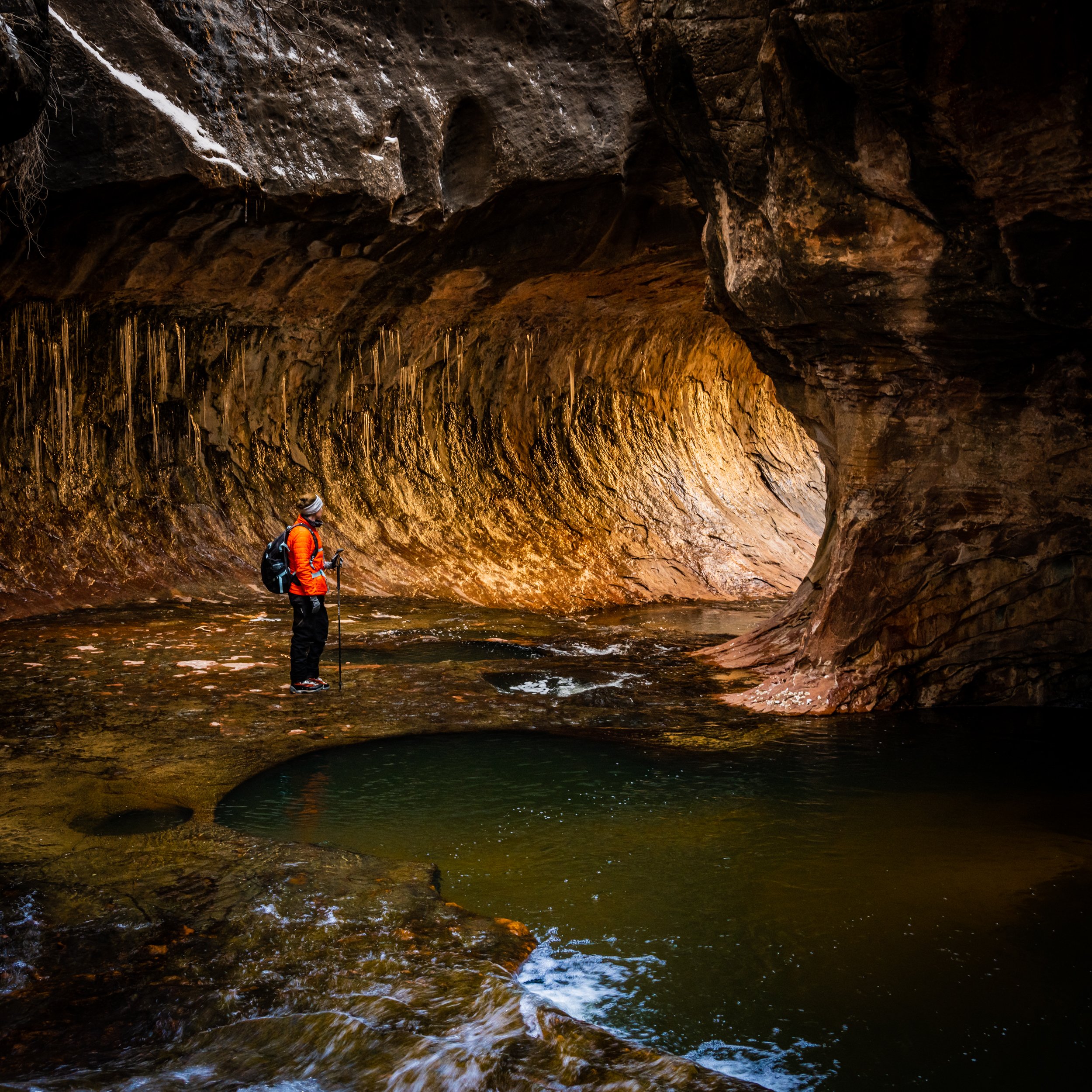
Eventually we started climbing up a wide and shallow stretch of creek and we noticed the walls were starting to close in and their shape was rounding. And then we came around a corner and could see the Subway. We had made it! Icicles were hanging off the ceiling and the sides of the creek were covered in thin sheets of ice. We had purchased some spikes to wear over our canyoneering boots if necessary but opted not to use them so we could exchange them for different gear we needed. Inside the Subway was really just everything you’d hope it would be. But it was also very, very cold. There was just no light making its way down toward us and yet a breeze was able to find its way to skim across the water surface. We had hoped to make it all the way to a waterfall that is impassable for amateurs (AKA, us) but we couldn’t make it that far because deep pools of water were blocking us. We were definitely not planning on immersing ourselves in the frigid water. Kelly took tons of photos, I wiped out once, falling on my butt into the shadow waters. Eventually we decided to depart and find a sunny spot to warm up while we ate some lunch. Right as we were leaving the formation, the ranger showed up and we got to chat with her. By the time she left the station, there had still been no other permits handed out.
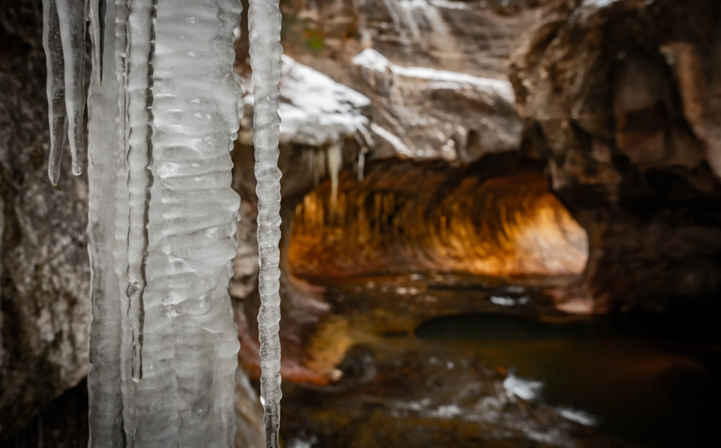
Icicles hanging off the rounded ceilings
The hike back felt a little less slow as we had experience with the specific obstacles and routes we’d be taking. And then eventually we had to make that 400 foot drop in reverse, huffing and puffing our way up the elevation gain. Have I mentioned Kelly was wearing snow pants under his Goretex pants? We stripped down to t shirts to regulate our temperatures and rejoiced at the chance to completely change back at the car. It had been exactly the kind of adventure we hoped to have but as usual, we had the next one on our mind. So we quickly changed, ate some snacks as we drove back to town, returned our rental gear and spikes, and drove across Zion toward Page, AZ where dinner, laundry, shower, and a warm hotel bed awaited us.
Know Before You Go. There are pit toilets at the trailhead but……. they were too disgusting to use the day we were there. No dogs, no drones. The water from the creek is not safe for drinking, even with filtering. So pack enough for the day. This is a permit required hike. And the park means it. Rangers patrol here almost every day. The trail is hard to follow and you need some route-finding and/or navigation skills. Our GPS device worked OK at locating us within the creek but often put us further ahead or behind than we were. We would never trust AllTrails on this hike. AllTrails is a popular hiking app but it is driven by user input and the case of this trail, the user input is really inaccurate. Both the Hiking Project and GaiaGPS worked well for us in terms of accuracy—especially in getting down to and out of the creek.